China
Satellite image of quake-striken Beichuan
Source: China Daily | 05-16-2008 14:51
Special Report: Strong quake jolts SW China
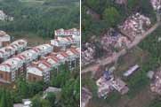
![This handout satellite image (L) taken by Taiwan's FORMOSAT-2 on Wednesday, May 14, 2008 and released on May 16, 2008, shows the areas (in brown) devastated by Monday's 7.8-magnitude earthquake in Beichuan County of southwest China's Sichuan province. The photo would compare the same areas in an image taken in 2006 (R). [Agencies]](http://www.cctv.com/english/20080516/images/1210921633275_1210921633275_r.jpg) |
| This handout satellite image (L) taken by Taiwan's FORMOSAT-2 on Wednesday, May 14, 2008 and released on May 16, 2008, shows the areas (in brown) devastated by Monday's 7.8-magnitude earthquake in Beichuan County of southwest China's Sichuan province. The photo would compare the same areas in an image taken in 2006 (R). [Agencies] |
Editor:Zhao Yan