Jordan
2009-08-19 16:42 BJTSpecial Report: Asia Pacific |
About Jordan
Jordan is a Middle Eastern country of 92,300 sq km situated in the great land bridge between Europe, Africa and Asia. It is bounded on the north by Syria, on the north-east by Iraq, on the east and south by Saudi Arabia, and on the west by Israel and the Palestinian National Authority. Six percent of the land is arable. The Kingdom's terrain provides a range of landscapes and climates. The Badia Plains lie to the east with mountains in the center . In the west the Jordan River flows through its fertile valley into the Dead Sea, the lowest point on earth. The Port of Aqaba in the south gives Jordan a narrow outlet to the Red Sea.
 |
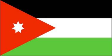
| Jodan flag |
Climate and Geography
Jordan has a combination of Mediterranean and arid desert climates, with Mediterranean prevailing in the North and West of the country, while the majority of the country is desert. Generally, the country has warm, dry summers and mild, wet winters, with annual average temperatures ranging from 12 to 25 C (54 to 77 F) and summertime highs reaching the 40 C (105-115 F) in the desert regions. Rainfall averages vary from 50 mm (1.97 inches) annually in the desert to 800 mm (31.5 inches) in the northern hills, some of which falls as snow in some years.
Jordan enjoys a range of geographical features, starting from the Jordan Rift Valley in the West ending at the desert plateau of the East, with a range of small hills running the length of the country in between.
Lowest Point: Dead Sea, -408 meters (-1338.6 feet)
Highest Point: Jebel Rum, 1734 meters (5689 feet)
Editor: Yang Jie | Source:

 Mail
Mail Share
Share Print
Print


 Video
Video


 2009 China Central Television. All Rights Reserved